Information about Santorini
Each of the islands of the province of Thera has certain characteristics in common: golden, black, and red sandy beaches, steep coastlines, pathways leading to the countryside with its spices, wild and cultivated plants, rocks, hills and mountains of interesting forms and colours, monasteries, country churches and farmhouses, compositions of folklore architecture and roads that lead to the small village squares.
Apart from these common characteristics, each island has its own special character like Anafi, for example, which is connected to the myth of the Argonautic Expedition, the volcanic islands Thera and Thirasia with their geological, prehistoric, classical, historical, Byzantine and medieval monuments, Ios - the island of Homer, Sikinos with its medieval castle in the centre of the settlement, Folegandros named after the son of the King of Crete - Minoa - and of Chrysospilia.
The Santorini group of volcanic islands possesses characteristics that are enough to satisfy even the most demanding visitor. Geological formations (caldera, volcanoes), antiquities (the settlement of Akrotiri dating back to prehistoric times and ancient Thera dating back to the classical period), Byzantine monuments (the Basilica of Aghia Eirini in Perissa, the Church of Panagia Episkopi in Mesa Gonia), medieval buildings (Kastelia and Goulades), post-Byzantine buildings (monasteries, churches). Also, endless pitch-black or deep red beaches, multi-coloured clifflike rocks, pathways, old thermal springs, the town and villages with their characteristic ecclesiastical and folk architecture. Luxurious or traditional hotels and restaurants, coffee shops and bars with unique views, seaside lodgings, restaurants and entertainment. These very special characteristics have made Santorini known not only as the number one tourist destination in Europe and the second in the world, but also as the most romantic island of Greece.
Geography
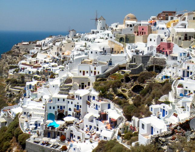
Santorini’ s group of islands is consisted of Thera, Thirasia, Aspronisi, Palea and Nea Kameni (Volcanoes) islands and is located in the most southern part of the Cyclades in the Aegean Sea, 63 nautical miles north of Crete. The surface area of Thera is 73 sq. km. and its population, distributed among thirteen villages, is 13.600 people, according to the 2001 census.
History
The human presence on the island seems to be existed since the middle of the 3rd millennium B.C. The excavation at Akrotiri has confirmed that man’s activity on the island continues until the eruption of the volcano in around 1500 B.C, which entirely buried the island beneath very thick layers of pozzuolona. All traces of human activity vanished from the island until the end of the 13th century B.C.
According to Herodotus, the island was initially called Strongyle (the Round One). Later, because of its beauty, it was called Kalliste (the Fairest One). To Kalliste, came the Phoenicians and there they settled. After the Phoenicians, the Lacedaemonians arrived and gave the island the name of their leader, Theras. In the 9th century B.C. Thera, became an important point on the communication route between the East and the West of that era and adopted the Phoenician alphabet for writing the Greek language. In about 630 B.C. Therans reached the north coast of the African continent where they founded Cyrene, the only Theran colony. During the Classical period in Greece (5th and 4th century B.C.) Thera did not play an important role in Hellenic events. During the Peloponesian War Thera sided with Sparta, as expected. In Hellenistic times the island’s strategic position made Thera a precious base from which the warring campaigns of the successors of Alexander the Great were launched in the Aegean.
Within the Roman Empire, Thera was nothing more than an insignificant small island. However, Christianity reached early the island and an organized church was already existed by the 4th century A.C. The island was of neither political nor military significance in Byzantine times although Alexius I Comnenus (1081-1118) founded the church of Panagia Episkopi at Gonia.
After the fall of Constantinople to the Crusaders of the Fourth Crusade (1204) the Duchy of Naxos was founded and Thera became the seat of one of the four Catholic Bishops of the Duchy. The name Santorini was given at that time by the Crusaders after the church of Aghia Irini (Santa Irene) which some say was at Perissa and others say was at Riva on Thirasia. In the years of Frankish rule (1207-1579) although Santorini experienced the development of cotton cultivation and viticulture, the island suffered as much from piratical raids as from the rivalries between the local Latin rulers or between the Duke and the Sultan.
The Turkish dominion (1579-1821) resulted in the abolition of piracy and the development of international trade. The Santorinians created close contacts with the great harbours of the Eastern Mediterranean (Alexandria, Constantinople, Odessa) where they founded important communities. In 1821, Santorini with its shipping strength, took part in the fight for independence from the Turks, and in 1830 became part of the independent Greek state. Up until the beginning of the 20th century shipping, textiles, tomato production and viticulture were all flourishing. The change from sail to steam-driven ships and also the transportation of the island’s factories to mainland Greece had a great effect on the island’s economy. After the 1956 earthquake there was a huge decrease in the population and an economic catastrophe. Towards the end of the 70’s tourism began to develop, bringing economic relief to the island.
The prehistoric town of Akrotiri
(By Christos Doumas, Professor Emeritus University of Athens, Director of the Akrotiri Archaeological Excavations)
Thanks to the digging up of deep pits for the foundation of columns for the new cover, it is now possible for us to outline the history of the prehistoric settlement on the southern coast of the island. Established during the Neolithic period (during the 5th millennium B.C.), the small Neolithic village followed the development of the Cycladic civilization of the 3rd millennium B.C. (proto-Cycladic period) and thanks to the strategic importance of its geographical location the cosmopolitan merchant harbour was built and today is admired by many visitors.
During the mid-Cycladic period (2000-1650 B.C.), the town of Akrotiri played a significant role in the transportation of commodities and in the development of metallurgical activities, making it a pioneer of progress not only in the Aegean, but in the Mediterranean in general. The material wealth created by these activities allowed the inhabitants of the town not only to survive after every catastrophe caused by a destructive earthquake, but also to rebuild and decorate the town with impressive buildings. Unique works of art that were saved in the ruins of each catastrophe constitute clear evidence of this continuous development. Artistic creations displaying a wide variety of colours, picture presentations and narrative scenes on the pot engravings of the mid-Cycladic period symbolize the advancement of the great painting that would come to decorate the walls of buildings with scenes from the life of the town during the next and final part of the period (late Cycladic 1). The tremendous volcanic explosion of the middle of the 17th century B.C., together with its consequences that affected the entire Mediterranean, suddenly broke the course of life for the people of Thera as it completely buried the island under a thick layer of volcanic deposits. However, it was thanks to this explosion that a final snapshot of the advanced course of a four thousand year old unique civilization was preserved.
An aspect that reveals the liberal character and somewhat “town” mentality of the society of Akrotiri more than any other is the extensive use and development of art. Not even one of the buildings that have been uncovered up until now lacks wall painting decoration in at least one of its rooms. It is as if the new town had been transformed into a huge laboratory where patrons and artists competed against each other to see who could best portray their social position on the one hand, and their artistic talent on the other hand. Moreover, one can interpret the large variety of subject matter, and in particular the depiction of exotic places with unknown animals and plants in the environment of the Aegean, as another source of rivalry amongst the widely travelled seamen of Akrotiri. Nowhere else in the Aegean can one witness similar competition.
Nevertheless, the town of Akrotiri had become a cosmopolitan merchant harbor just as the exotic objects that have emerged from its ruins confirm. The rich and widely travelled seamen competed with each other in decorating their homes with wall paintings with subject matters that portrayed their own identity. The exotic places with the flora and fauna that was unknown in the Aegean inspired admiration amongst craftsmen and manual workers of the land whilst simultaneously were raising the prestige of those who contributed to the town’s wealth, of the merchants and of the seamen. However, this wealth gradually transformed the character of the town’s inhabitants. Any archaeologist who delves into the ruins of the town has the feeling that he is witnessing the history of a consumer society.
The city of Ancient Thera
(By Maja Efstathiou, Archaeologist in the 21st Ephorate of Prehistoric and Classical Antiquities, Ministry of Culture)
In the early of eighth century B.C. when Dorieis colonists arrived in the island, possibly Spartiates, with their leader Theras, founded the settlement which took their leader’s name in the steep, embattled peak of Mesa Vouno, which is a hill (385 meters) that belongs to the pre volcano core of the island and predominates in its southeastern end. Cobbled streets in Sellada’ s slopes, the sol that unites the hill with the mountainous bulge of Prophet Elias in the northwest, were connecting the city with the coastal territories in the foothill of Mesa Vouno, where its seaport settlements, Ia in the north (Kamari) and Eleysis in the south (Perissa) were founded. Today, Sellada offers once again the access to the archaeological site (road from Kamari - pathways).
The city was inhabitable for more than thousand years and was the administrative and religious centre of the city-state of Thera, which was consisted of six more settlements. The city met a particular construction development during the Hellenistic period, a time when Thera was conquered by the dynasty of Ptolemaios, King of Egypt because of its strategic position in the Aegean. From the 3rd century A.C. the city is being gradually abandoned and in the early Christian times the city is no longer at its peak, but it is still inhabitable. In the 8th century the city offers settler to the residents of the seaport settlements from the Arabs’ invasions, where they started knocking up settlers among the ruined buildings of the city with construction materials from the ancient buildings.
ven if the continuous inhabitancy ruined the majority of the remains of the early periods, the city was excavated in great extent by German scientists under Hiller von Gaertringen (1896-1902) supervision and gives a complete picture of its shape and organization during the Hellenistic and Roman period, while the number of the inscriptions and mobile findings discovered in the city and in its cemeteries –many of them are exhibits in the Archaeological Museum of Fira– are the main source of information for the island’s history in ancient times.
The city which is built 320 meters above sea level has a central road that runs through it (North/Northwest-Southeast) and holds the elongate line of the hill. Its core develops in consecutive embankments on the smoother east side while the ends and the steep points of the line host mostly worship places. The construction of strong footholds the one after the other and the frequent use of the offered rock manifest the efforts of the people to tame the inclined and rocky of its soil while the numerous underground wells, testify the solution that people had found to store water.
Public buildings, markets, stores, theatre, baths, districts with private residences, temples, sacred places and one complete road network with sewerage system constitutes the city’s picture, in which austere architectural figures prevail. The “Market of Gods” in the south side was the most important place of worship, where the sacred of Apollo Karneios, the God of Dorieis, predominated in the religious life of Thera and numerous inscriptions on the rocks preserve the most ancient pieces of the Greek Alphabet in the Aegean.
The importance of the archaeological site which had been abandoned for decades due to the lack of credits, was forced the 21st Ephorate of Prehistoric and Classical Antiquities to create the project “Configuration and Emergence of the Archeological Site of Ancient Thera”, which was included in the Peripheral Corporate Program (PCP) of South Aegean 2000-2006 and was co-sponsored from European Union by 75% and from the Greek State by 25%. The project has already accomplished its targets in the areas of enhancing and protecting the monuments, as well as in the fields of arranging and organizing the site, and finally in informing the visitors. In 2008, when the project is completed, its primary task is the organizing of the archeological site’s entrance, and the securing of the infrastructure basis for the services of the visitors.
As the visitors walk through the cobbled streets of the ancient city among buildings that are usually very high, they can realize its shape and its organization, know its monuments and feel the life of its residents, enjoying at the same time the magnificent view to the Aegean.
Tradition is alive in Santorini
Visitors of Santorini discover, with pleasant surprise, that even today tradition is preserved in Santorini at its small village communities.
Religious festivals called “ayiomnisia”, wedding celebrations with traditional customs and local musical instruments that accompany the procedures of a wedding ceremony, local food such us split peas and tomato balls, desserts like ‘melitinia’ (Easter sweets) and “koufeto” (wedding sweet), animals that still help both with agricultural work i.e. ploughing and threshing and transportation, houses decorated with old furniture, utensils, old handmade embroidery, old paintings and photographs, canava wineries where grapes are crushed and wine is produced by the viticulturists themselves, these are just some of the aspects of tradition that is so alive in Santorini.
Visitors should aim at knowing and experiencing these and other customs of a tradition that is very much alive, in order to get a complete picture of this peculiar volcanic place and its inhabitants.